

Garmin Basecamp™ - So much more than Mapsource™
BaseCamp™
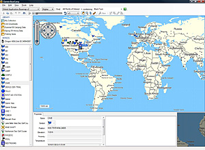
Take charge of your next adventure with BaseCamp, software to view and organize your maps, waypoints, routes, and tracks and send them to your Garmin device.
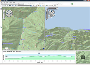
Survey the Terrain
BaseCamp displays your topographic map data in 2-D or 3-D on your computer screen, including elevation profiles. Then you can view and rotate the maps from any angle.
For the highest level of topographic detail available, check out TOPO U.S. 24K maps for your outdoor handheld, comparable to 1:24,000 scale U.S. Geological Survey (USGS) maps.
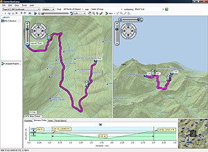
Plan Your Route
Prepare for you trip by creating waypoints and routes on your computer and then loading them to your device.
Estimate the difficulty of your hike before you start with BaseCamp’s Track Draw feature to trace your intended path. Instantly view the elevation changes over your entire route. When your trip is done, BaseCamp shows an animated playback of your routes and tracks over time, so you can see where you’ve been.
To add extra detail to your handheld, try detailed TOPO U.S. 100K maps, comparable to 1:100,000 scale USGS maps and available on DVD or microSD™ card.
Geotag Photos
BaseCamp lets you geotag photos — add a photo to any waypoint on the map — so you know exactly what the scenery is like at any given location. You can even transfer the photos to and from your Garmin device.
Transfer Satellite Images
With BaseCamp and a BirdsEye Satellite Imagery subscription, you can transfer an unlimited amount of satellite images to your Garmin device and seamlessly integrate those images into your handheld’s maps to get a true representation of your surroundings.
- View 24K or 100K topographic maps and other topographic data.
- Displays maps in 2-D or 3-D, including elevation profiles.
- View and rotate maps at any angle.
- Create waypoints and routes on your computer and transfer maps, waypoints, routes, tracks and geotagged photos between your computer and device.
- Transfers satellite images to your device (with the purchase of BirdsEye Satellite Imagery subscription).
- Shows animated playback of routes and tracks over time.
- Supports geotagged photos.
- Easily organize data into folders.
- Prints full-page, color maps.
- Exports user data for viewing in Google Earth™.
- Includes advanced geocaching support; can import data from geocaching.com.
- Use your unit's preloaded map (requires unit to be plugged in via USB) to plan your trips.
 Share Article